Wild Weather Wrap-up - Lots of Weather-related Training and Information
So with all of the historic weather we’ve had here with the remnant low of Hurricane Ida causing 7 tornadoes and severe flooding, I figure that I would share and highlight some of the most important to know weather related information available on the ARES of Delaware County website.
Weather Information & Links |
|---|
Here you’ll find general weather information, links to helpful websites and apps, as well as training that may be helpful. Websites
Applications
Training
Tools
Measurements
|
How to Locate Tornado on Radar |
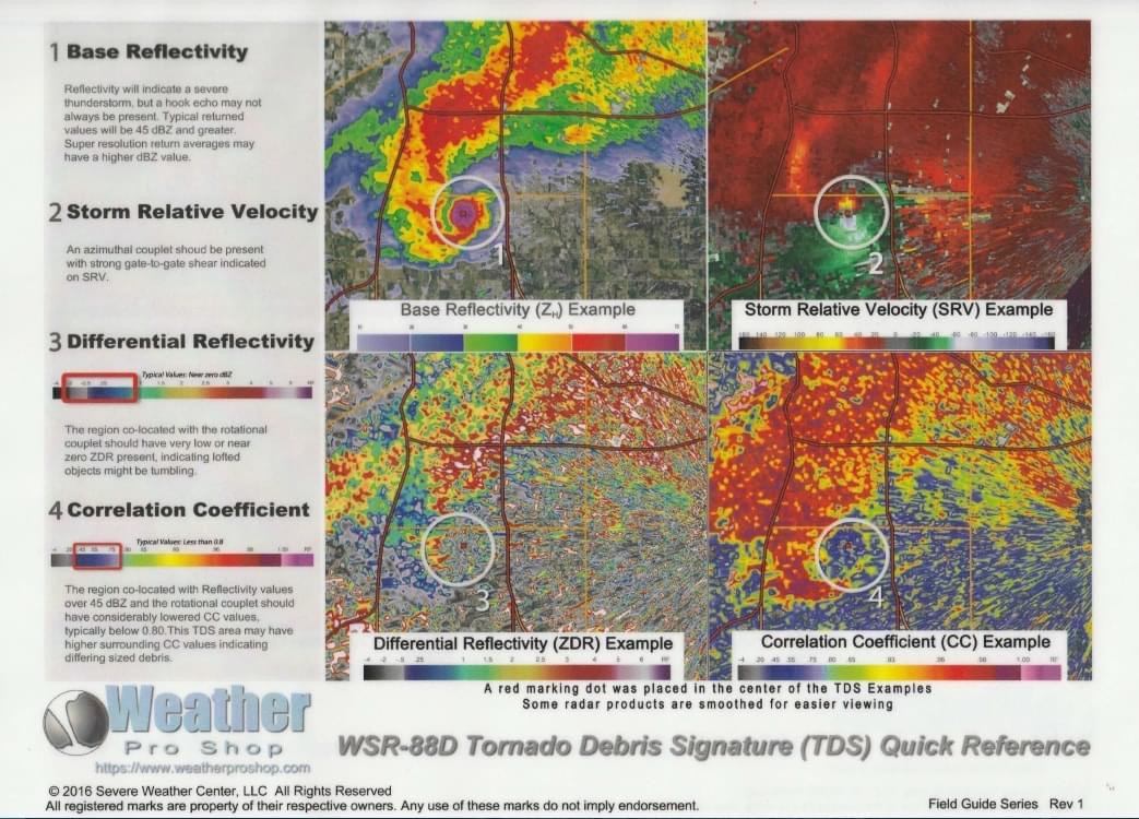
Tornado Debris Signature
WSR-88D Tornado Debris Signature (TDS) Quick Reference
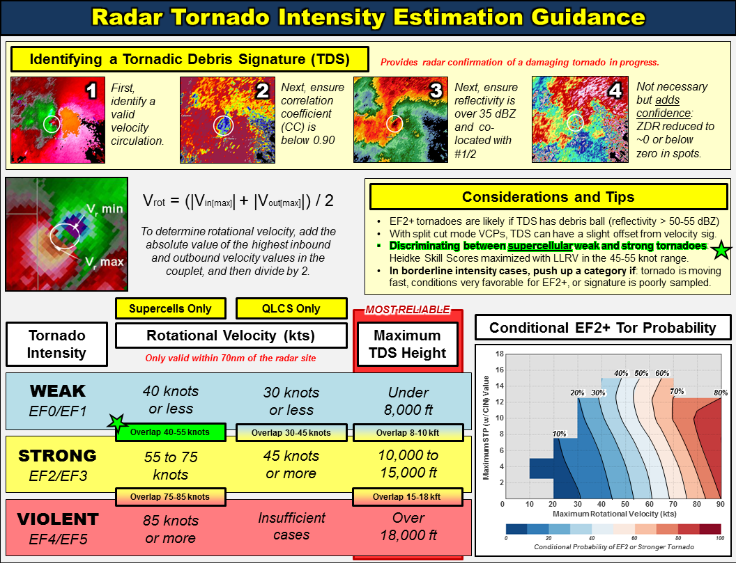
Tornado Intensity Guidance
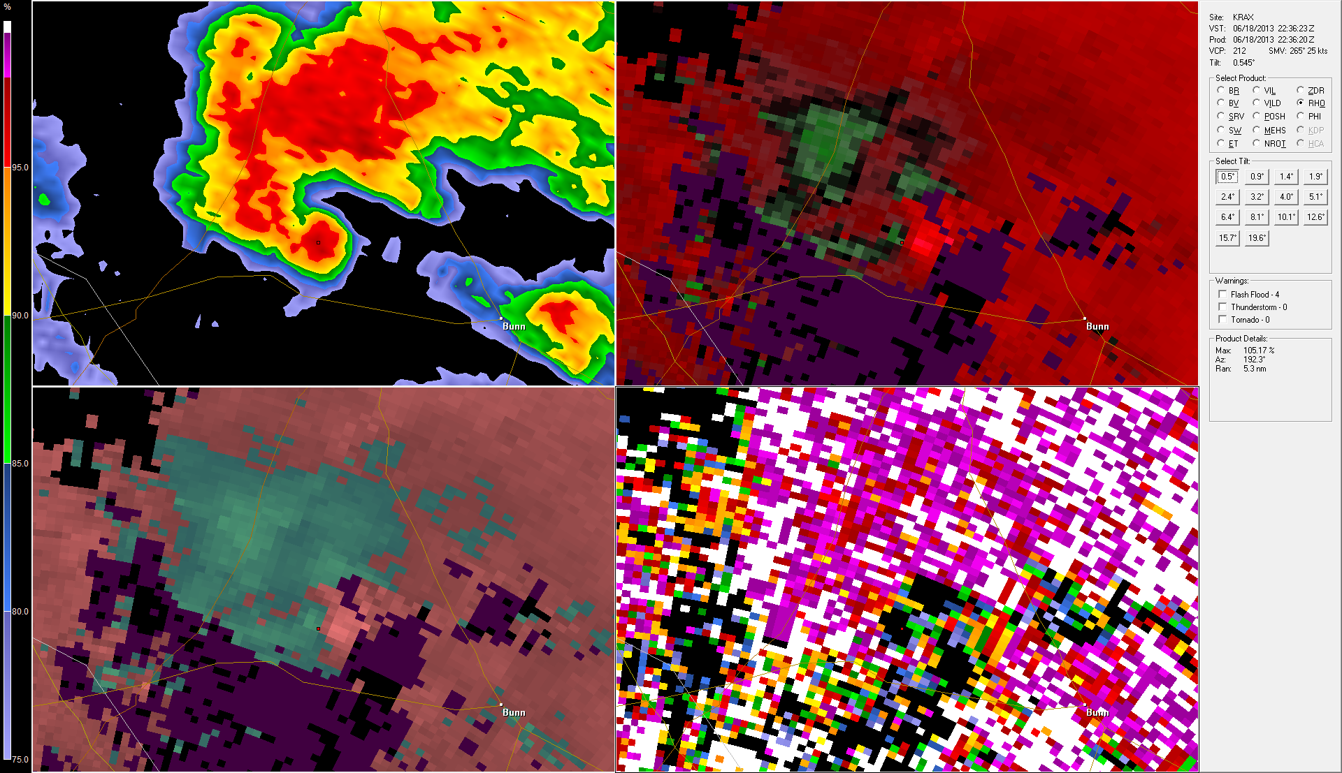
Example Radar Image
|
SKYWARN Spotter Weather Training |
SKYWARN is a self-contained network of certified weather spotters sponsored and trained by the National Weather Service (NWS). Many spotters are Amateur Radio operators who submit observations via radio. Compiled observations are forwarded to meteorologists at local NWS offices and the data is incorporated into reports and forecasts. SKYWARN volunteers collect on-the-spot weather observations in localized areas that assist NWS meteorologists in producing forecasts that are more accurate and warnings that are more timely. Online SKYWARN Training OptionsYou only need to complete one of the Basic courses listed to become a spotter:
The local NWS offices would occasionally hold these course in-person, however most options are all online for now. SKYWARN Spotter Registration for Mt. Holly Office - in order to register your information and obtain your Spotter ID. You can always report weather to your local NWS office, but reports from spotters and local emergency management agencies are always considered to be more accurate. Once you get your Spotter ID, you can also add to your knowledge with the advanced spotter course. If you have ever wondered how to spot a tornado on weather radar using both reflectivity and velocity returns, this is for you.
|
FEMA Weather Awareness Courses |
These weather awareness courses go more in depth into specific weather threats and are extremely helpful. These are offer through FEMA and there is no charge to signup and attend. They are held both in person and online via video conference. Easiest way to find these classes is on the FEMA First Responder Training schedule: https://www.firstrespondertraining.gov/frts/schedule One of my favorite providers for online offering has been the National Disaster Preparedness Training Center (NDPTC): https://ndptc.hawaii.edu/training/?course=&state=&start= |